Complete Guide to ZIP Codes: Everything You Need to Know
Discover everything about ZIP codes with our comprehensive guide. Learn what ZIP codes are, how to find your ZIP code, and use Geocodio's lookup tools for accurate address data.
What is a ZIP Code?
ZIP codes are the handy postal code system used by the United States Postal Service (USPS) to sort and deliver mail efficiently. The name "ZIP" actually stands for "Zone Improvement Plan," which was introduced in 1963 to help mail reach its destination more reliably.
Think of ZIP codes as an address for your address! They consist of five digits that identify specific geographic regions across the United States. There's also an optional four-digit extension (ZIP+4) that narrows down the location even further.
How to Find Your ZIP Code
What is my ZIP code?
If you're wondering about your own ZIP code, here are some simple ways to find it:
- Check your mail: Look at any recently received mail or packages - your ZIP code is right there in your address.
- USPS ZIP code lookup: The official USPS ZIP code lookup tool can help you find any ZIP code.
- Geocodio's ZIP code lookup: Need a more comprehensive solution? We provide accurate ZIP code information for any address in the United States.
Understanding ZIP Code Formats
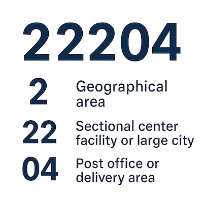
Standard 5-Digit ZIP Codes
The five-digit ZIP code is like a geographic address system, with each digit helping to narrow down a location:
- First digit: A broad geographical area (0-9)
- Second and third digits: A sectional center facility or large city
- Fourth and fifth digits: A specific post office or delivery area
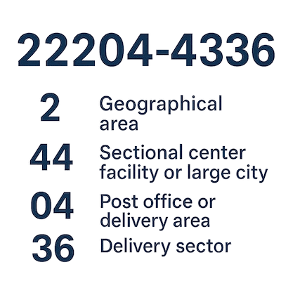
ZIP+4 Codes
The ZIP+4 extension adds four more digits to make mail sorting even more precise:
- First two digits: Delivery sector (several blocks or a large building)
- Last two digits: Delivery segment (specific floor or department in a building)
Using Geocodio for ZIP Code Lookups
We've designed our tools to make working with ZIP codes straightforward and reliable, whether you need to look up one address or process thousands.
How Our ZIP Code Lookup Works
- Single Address Lookup: Simply enter any U.S. address, and we'll provide the accurate ZIP code information.
- Batch Processing: Need to process many addresses? Upload thousands (or even millions) at once and receive ZIP codes for all of them quickly and affordably.
- API Integration: Seamlessly integrate our ZIP code lookup functionality into your applications or websites.
Why Use Geocodio for ZIP Code Lookups
- Reliable Results: We use up-to-date USPS data to ensure you get accurate ZIP code information.
- More Than Just ZIP Codes: Along with ZIP codes, we provide additional geographical data like census tracts and legislative districts.
- Simple to Use: Our user-friendly tools and flexible pricing make ZIP code lookups accessible for projects of any size.
Common ZIP Code Questions Answered
Why are ZIP codes important?
ZIP codes serve multiple important purposes:
- Help mail reach its destination efficiently
- Provide geographic identification
- Support statistical analysis for demographics
- Assist with business market analysis
- Aid emergency service coordination
How many ZIP codes are there in the United States?
There are approximately 42,000 ZIP codes across the United States. This number changes from time to time as new codes are added or existing ones are modified.
Can ZIP codes cross state boundaries?
Yes, though it's not common, some ZIP codes do cross state lines. This typically happens in areas where state boundaries run through densely populated regions.
The Evolution of ZIP Codes: A Brief History

ZIP codes haven't always been part of our mailing addresses. In fact, they're a relatively modern innovation that transformed how mail delivery works in the United States. Let's take a journey through the key moments that shaped the system we use today:
1943: City Postal Zones Introduced
The story begins during World War II, when the postal service faced staffing shortages as experienced postal workers joined the military. To help new employees sort mail more efficiently, the Post Office Department introduced a numbering system for 124 of the largest cities. For example, "Detroit 2, Michigan" meant a specific zone in Detroit.
July 1963: ZIP Code System Launched
Twenty years later, as mail volume grew dramatically in the post-war boom, the USPS introduced the Zone Improvement Plan - giving us the acronym "ZIP." This nationwide five-digit system revolutionized mail sorting by creating a more precise geographic identification for every area in the country. The famous "Mr. ZIP" cartoon character even helped promote adoption of the new codes!
1967: Adoption Becomes Mandatory
While many people embraced the new system, others were slower to adopt it. By 1967, the Post Office made ZIP codes mandatory for bulk mailers, which helped standardize the system across the country. This change ensured more reliable and faster delivery for everyone.
1983: ZIP+4 Extended Codes Introduced
As communities grew and mail volume increased, the USPS needed even more precision. The ZIP+4 system added four more digits to identify specific segments within a delivery area - right down to a city block, apartment building, or even a single high-volume mail recipient. These additional digits helped automate sorting further and speed up delivery times.
Today, ZIP codes have become more than just a mail sorting tool. They help emergency services respond faster, businesses analyze markets, researchers study demographics, and mapping services navigate more accurately. What started as a simple sorting solution has evolved into an essential part of our geographic identification system.
At Geocodio, we understand the importance of accurate ZIP code data for your projects, which is why we maintain up-to-date information to ensure your addresses are processed correctly every time.
ZIP Codes for Business Applications
Market Analysis
Businesses rely on ZIP codes to:
- Identify potential target markets
- Understand customer demographics
- Plan strategic expansion
- Optimize delivery routes
Customer Location Intelligence
With Geocodio, you can:
- Enhance customer databases with accurate ZIP code information
- Analyze how customers are distributed by region
- Tailor marketing strategies based on geographical data
- Improve logistics and delivery planning
Advanced ZIP Code Applications with Geocodio
Reverse Geocoding
Beyond finding ZIP codes for addresses, we also offer reverse geocoding:
- Convert coordinates to addresses with ZIP codes
- Identify ZIP codes from a map location
- Look up ZIP codes for specific areas
Data Enrichment
We enhance ZIP code data with valuable information:
- Demographic details
- Income statistics
- Housing data
- Educational metrics
- Congressional districts
Conclusion
Whether you're asking "what is my ZIP code?" for personal mail or need comprehensive ZIP code data for business purposes, understanding how ZIP codes work and using reliable tools can save time and improve accuracy.
Our user-friendly interface and robust API make working with ZIP codes simple and efficient for any use case.