Getting Started
What you can do with GeocodioSpreadsheet formattingAddress completionSpelling CorrectionFile formatsFile sizesIntersectionsPreviewing your spreadsheetReverse geocodingGoogle Maps API CompatibilityData Appends
Data Enrichment OverviewCensus Block/Tract/FIPS/GeoIDUSPS ZIP+4 (Full ZIP9)Congressional Districts & Contact InfoState Legislative DistrictsCensus: DemographicsCensus: Education & Veteran StatusCensus: FamiliesCensus: HousingCensus: IncomeFFIEC DataOCD IDsSchool DistrictsProvincial/Territorial RidingsFederal RidingsCanadian Census GeographiesTimezonesTroubleshooting
Country supportMap preview shows AfricaMissing coordinatesRow estimate too highSYLK ErrorTestingWhy are latitudes/longitudes slightly different when reverse geocoding?What happened to counties in Connecticut?What is a Census Block Group?Missing Leading Zeroes In SpreadsheetCongressional District 00 or 98Access Not Allowed ErrorBilling & Payment
Sales TaxesW-9Pay-As-You-Go CreditsEstimates/QuotesSet a usage limitWhat's a 'lookup'?When will I be charged?Why are latitudes/longitudes slightly different when reverse geocoding?
After uploading a spreadsheet for reverse geocoding, you will likely notice your spreadsheet looking something like this:
Note: The first pair of coordinates represents the input, the second pair of coordinates represents the output from Geocodio.
| lat | long | Latitude | Longitude | Accuracy Score | Accuracy Type |
|---|---|---|---|---|---|
| 36.605976 | -78.324997 | 36.606299 | -78.325189 | 1 | rooftop |
| 40.748433 | -74.826555 | 40.748704 | -74.827256 | 0.99 | rooftop |
In addition to the submitted coordinates, Geocodio will append a Latitude and Longitude column with the actual location that was geocoded.
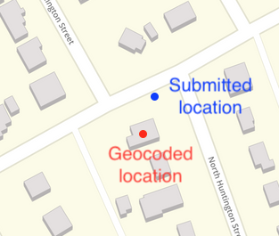
The location is often slightly different, as Geocodio will "snap" to the nearest matching address.
Here's an example of what that looks like:

The submitted coordinate is on the lot, but closer to the street. Geocodio returns the rooftop coordinate, directly on the building.
Generally, we will "snap" to locations that are within a 500 foot threshold. If the nearest location is further away, we will fall back to a lower accuracy type such as nearest_street or nearest_place.